All sites marked with an asterisk
* can be found on
http://www.megalithomania.net/
This weekend I visited the following sites mostly on the Beara Peninsula.
1/ Uragh stone circle. (west) *
2/ Uragh stone circle. *
3/ Ardgroom outward. *
4/ Kilmackowen standing stone and wedge tomb. *
5/ Killaugh wedge tomb.
6/ Derrenataggart (west) stone circle. *
7/ Inchincurka wedge tomb. *
8/ Kilmicheal memorial.
9/ Derryfinneen standing stone.
10/ St Abban's well. *
Click on images to enlarge.
1/ Uragh stone circle (west). OS Map no 84.
 |
| Boulder burial in center of circle. |
 |
| 2 Boulder burials outside and adjacent to circle |
 |
| Looking over boulder burials into circle |
 |
| Stone circle from an overlooking rock,pity about the gorse bush! |
 |
| From opposite side. |
 |
| My favourite stone in circle. |
 |
| General view from circle. |
Unfortunatly I lost a lot of time at this site looking for it. The farmer has signs up pointing to famine house,fulacht fia, hut circle, boulder burial and stone circle which I followed much against my instinct.... I found the famine house.... pictured below...
and thought ok I'm on the right track.....big mistake...an hour or so later I decided to go back to where I started and trust my instincts and my trusty os map. Then I came across this....
 |
| And this |
 |
| Photo taken in front of hut circle sign,but try as I might I couldn't find it. |
After that last photo there were arrows tacked onto trees pointing the way to boulder burials,but at this stage I was sticking like glue to my os map and finally I came across the stone circle and the boulder burials beside it. The arrows in fact were pointing in the right direction.......
2/ Uragh stone circle. os map 84.
 |
| As I first saw it. |
 |
| Impressive standing stone,circle and background !!! |
 |
| Looking down from a knoll nearby. |
 |
| The standing stone is pretty big about 4 metres or so. |
 |
| Parting shot. |
This circle is in a stunningly beautiful location. I think circle is a bit of a misnomer though, its not very circular. I really enjoyed visiting these two circles despite losing some time. Two more quick photos here....
 |
| You just have to smile. |
On the left hand side of the bridge on the photo above theres an entrance gate and on the way out I met the farmer who owns the land,he was coming in as I was going out and he held the gate open for me. I stopped to thank him and he offered me some post cards for sale I declined but he kept chatting away a very friendly and elderly man. The more we chatted the more I liked him...... so he made a mistake putting an arrow the wrong way on one of his signs but his heart's in the right place....... I wish him luck and I'm glad I put the €2 in the box....
3/ Ardgroom outward. os map no 84.
 |
| Tasteful weatherproof sign good to see. |
 |
| Approach to circle with outlier on left. |
 |
| Outlier. |
 |
| My favourite stone in circle. |
 |
| Objects left on stone in centre of circle. |
 |
| Gate and style makes access easy. |
I liked this circle from the moment I saw it in the distance from the road. Its fairly stark with its very pointed stones. There's some thought been put into ease of access and presentation. Its on the Beara-Breifne way as are other stone circles in this vicinity. The approach up the slight hill is very very wet but flagstones have been placed to help with this. I don't know what people hope to achieve by leaving stuff on the stone in the centre of the circle.....each to his own I suppose....
4/ Kilmackowen standing stone and wedge tomb. os map no 84
 |
| Face 1 |
 |
| Face 2 |
 |
| With its attendant shadow |
 |
| Side shot.. it's pretty thin for its size. |
 |
| Wedge tomb |
 |
| Line of stones behind tomb... |
 |
| Half way down field with stones protracting from tomb. |
 |
| Stones continuing down hill heading for standing stone.... |
 |
| Looking back towards wedge tomb. |
This standing stone is about 3.5 metres high and leans forward more than the eye can tell on walking up the field towards it. Its also pretty thin width wise.
The wedge tomb stands in the corner of the field beside it and at first is hard to spot. An unusual feature here is a row of stones which runs from behind the tomb to in front of the tomb in a very gentle arc down the hill towards the standing stone. I've never seen anything like this before. Anybody got any explanations or theories?
5/ Killaugh wedge tomb. os map no 84
 |
| Location of tomb on os map no 84. |
 |
| As I first saw it in middle of field from the road. |
 |
| From the side. |
 |
| Large rock slab at back of tomb. |
 |
| From the side with double wall at the back of tomb. |
 |
| The front with sinking sun behind. |
 |
| Cup marks on cap stone. |
This tomb is on os map no 84 Grid reference V569 421. Although its spelt Killough on the map its spelt Killaugh on the sign pointing to it from the road. If you are driving on the R575 from the Allihies direction you will come to a road sign pointing right to Garnish and Dursey islands the R572, the tomb is in the middle of the field to your left at this junction.
The tomb is orientated south/west. It is comprised of 5 stones made up of two side stones,a double back stone and a capstone. The capstone has cup marks on its top. I was lucky to catch it at the right time just as the sun was sinking behind the hill behind it,casting the tomb in a beautiful golden glow.
6/ Derreenataggart (west) stone circle. os map no 84.
 |
| As I first saw it |
 |
| Looking over axial stone to the one remaining standing portal. |
 |
| Fallen portal. |
 |
| Standing portal. |
 |
| Broken in half stone at centre of circle. |
 |
| My favourite stone. |
I really loved this circle, its got a lot of character.
Ive not got much more to say here, will just let the pictures speak for themselves.
7/ Inchincurka wedge tomb. os map no 85.
 |
| Overgrown side. |
 |
| Cup marks on capstone. |
This tomb looks really nice where it sits in its field. Unfortunately its getting very overgrown by brambles. Its well worth a visit though.
8/ Kilmicheal ambush memorial.
I passed this memorial on my travels.....
Here's a link to a site to explain this picture....
http://www.kilmichael.org/hisambush.htm
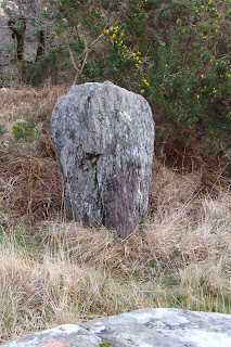
9/ Derryfinneen standing stone os map no 85.
Passed this standing stone on my way to Ballyvourney and took a couple of photos.
10/ St Abban's well os map no 79 (Ballyvourney)
This was a loose end left over from my previous trip to Cork weekend before last. Just had to get a photo of this well which I didn't get last week end.
For previous blogs look down to next panel and click older posts


