I spent last weekend visiting the following sites in Co Cork
1/ Labbacallee wedge tomb.* 2/ Island wedge tomb.* 3/ Island standing stone. 4/ Mourne Abbey and Barrets Castle.
5/ Warren cross standing stone. (Rosscarbery)
6/ Drombeg stone circle, hut circle and fulacht fia* 7/ Reanascreena stone circle.*8/ St Gobnait's church, holy well,bullaun stones and Sheela
na gig.*
9/ Bawnatanaknock standing stone.
10/ Knockraheen stone circle, standing stones, and cairn.*
11/ Standing stone. 12/ Wedge tomb. 13/ Standing stone.
14/ Knocknakilla standing stone.* 15/ Knocknakilla stone circle,standing stone & radial cairn.*
16/ Questionable site (???) 17/ Rostellen portal tomb.*
18/ Castlemary wedge tomb. 19/ Bweeng wedge tomb.*
1/ Labbacallee wedge tomb.
OS Map no 73. Grid Ref R 773 025.


OS Map 80 Grid Ref W 604 907.


I was very taken with this tomb. I love the two entrance stones, they give the whole monument a terrific visual structure and to me the very front of the tomb sort of looks like a court. In photo no 3 one can clearly see the wedge shape from front to back. Photos 4 & 5 show the double walling to good effect. The farmer on whose land this is couldn't have been more helpful and although it was pouring rain he insisted on accompanying me and showing me the tomb. He was there while it was being excavated in 1957 and he's obviously very proud of it.
3/ Island standing stone.
OS Map 80. Grid Ref W 608 912.

 |
| Not so much standing as leaning. |
 |
| I'm leaning in the rain, I'm leaning in the rain...... |
OS Map 80. Grid Ref W 572 923.


 |
| The castle stands on a hill overlooking the abbey. |

By the time I got to this site it had stopped raining and the evening was beginning to close in fast. Here's two links that will explain these sites better then I can.....
http://en.wikipedia.org/wiki/Mourne_Abbey#History
http://www.castlestories.net/Ireland/County-Cork/Castle-Barrett.html
One more bit of history here, this was also the place where a failed ambush took place during the Irish war of Independence...... http://homepage.eircom.net/~corkcounty/Timeline/Mourne%20Abbey.htm This was my last site of the day.
5/ Warren standing stone (Rosscarbery)
OS Map 89. Grid Ref W 295 361.


 |
| With the beautiful town of Rosscarbery showing behind in the very early morning sun. |
 |
| Taken en route to my next site,just love the way the early morning mist enfolds and hugs the hills. |
OS Map 89. Grid Ref W 246 352.

This is a site I have been wanting to visit again for a long time now,was last there many moons ago. I arrived here just after 8am and had the place to myself till around 9oc...... Don't care what anyone says this is still a great site and situated in a beautiful place. Because I had the place to myself and the sun was not long risen and the mist was still lingering around,I was lucky to be able to savour the atmosphere and ambiance of this site. Its not as sterile as I had expected it to be from looking at relatively recent photos. The fact that the grass has almost completely grown back in the centre of the circle rather than just having ugly gravel makes all the difference.
 |
| I like this photo...... Would look good on a postcard... |
 |
| General view of circle. |
 |
| Looking through portal stones towards axial. |
 |
| Looking over axial towards portal stones. |
 |
| The two portal stones. |
 |
| Axial stone with its two flankers. |
 |
| The two portals from inside the circle. |
 |
| My favourite stone...theres always one! |
 |
| Full of character...... |
 |
| Couldn't resist..... |
 |
| General view of fulacht fia and well |
 |
| Well beside fulacht fia. |
 |
| Fulacht fia. |
 |
| Conjoined hut circles |
 |
| Conjoined hut circles. |
OS Map 89. Grid Ref W 264 411.


 |
| The whole circle was waterlogged ! |
 |
| Looking through portal stones at axial stone. |
 |
| Looking over axial to portal stones |
 |
| Portal stones from inside circle. |
 |
| Axial stone. |
 |
| My favourite stone in circle. |
 |
| Horses standing guard at gate to field with circle. |
 |
| This guy was definitely the boss. |
As to the circle itself, it stands in a very waterlogged enclosure with an electric fence around it which happily wasn't working. I whiled away a very pleasant half hour here....just me the birds the horses and the stone circle.
8/ St Gobnait's church, holy well, bullauns and Sheela na gig.
OS Map 79. Grid Ref W 198 768.


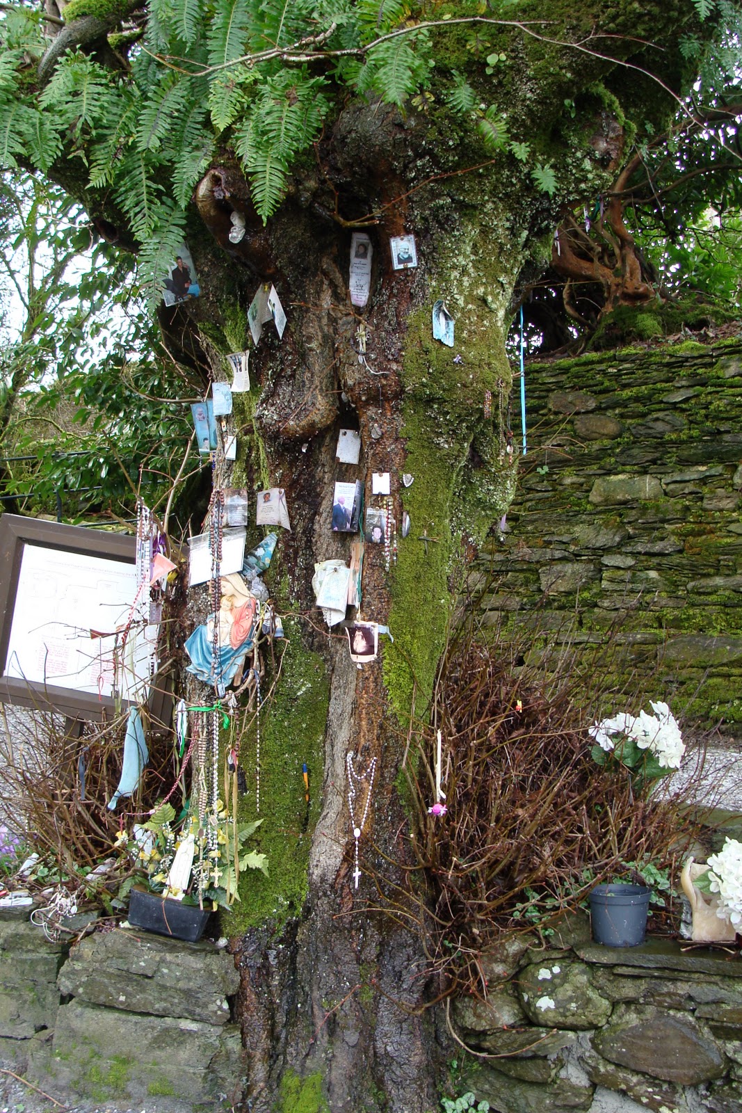
I'll let the pictures speak for themselves here.This is an extremely religious holy well. Even the rag tree isn't a rag tree as such,its festooned with rosary beads,scapulars.memorial cards.and other religious objects.
 |
| Ruins of St Gobnaits church |
 |
| St Gobnaits grave.... I agree with T4W about it being a cairn... |
 |
| Bullaun stone at St Gobnait's grave. |
 |
| Bullaun stone at St Gobnait's grave.... Its seen better days I'm afraid.. |
 |
| Location of Sheela na gig. |
 |
| Close up of Sheela na gig. |
 |
| Unusual carved stone head. |
 |
| Location of stone head.... Can you spot it...... click on picture to enlarge. |
OS Map 79. Grid Ref W 259 774.

 |
| Another one for my growing collection...this one is pretty unremarkable though. |
OS Map 79. Grid Ref W 305 803.


 |
| Two gorgeous standing stones with the cairn behind. |


 |
| Cairn . |

 |
| My first "Orb" lol. |

11/ Standing stones

12/ Wedge tomb.

13/ Standing stone.

14/ Knocknakilla standing stone.
OS Map 79. Grid Ref W 288 851.


15/ Knocknakilla stone circle,standing stone & radial cairn.
OS Map 79. Grid Ref W 297 841.

 |
| 3 stones of stone circle remaining,standing stone & fallen long stone. |
 |
| Fallen standing stone. |
 |
| Stone circle. |


 |
| Standing stone. |

 |
| Radial cairn. |

16/ Questionable site ???

17/ Rostellan portal tomb.
OS Map 81. Grid Ref W 875 673.

 |
| Love at first sight. |

 |
| Just to illustrate the seaweed hanging off the tree. |
 |
| A |
 |
| B |
 |
| C |
 |
| D |

 |
| Looking down river towards the sea. |
 |
| Looking up river towards Cork. |
This was definitely the highlight of my trip. Although its a nice portal tomb its the unusual setting that really makes it. Getting down to it is a bit of an adventure in itself. Pictures A,B,C, and D are to show the tomb in detail. A word of warning here if your going to visit this site, check the tide times and wear wellie boots. Here's the directions for getting there. Park your car in the Rostellan woods car park clearly marked on OS map no 81. Take the path (track) in front of you after the barrier going straight down through the woods,when you reach a T junction on the path (about 3/4 kilometre) turn right and follow track till its end. At this juncture go left into the woods and follow small path keeping to your right until you see a long field on your right (this field was ploughed when I was there but I guess it wont always be so). Enter the field and skirt down along its side keeping the woods on your left. When you reach the end of the field turn left into the woods for a short distance and you will see a steep rocky bank on your right leading down to the estuary. Scramble down here as best you can and you should see the tomb about 100 metres to your left. Take my word for it, its well worth the effort.
18/ Castlemary wedge tomb.
OS Map 81. Grid Ref W 898 678.

 |
| Castlemary castle. |


This tomb is on private land and permission is needed to visit but the people are nice and there should be no problem. It dosent seem to be well known and its not marked on the ordinance survey map though the castle in which grounds it stands is. The castle was burned down during the Irish war of independance in reprisal for the burning of Cork by the black and tans.
19/ Bweeng wedge tomb.
OS Map 80. Grid Ref W 508 889.


This I'm afraid was one site too far for me. This was as close as I got to it, looks like a great site though....can't wait to get back here. I had to wait for the correct times for the tide at Rostellan and then I spent quite a lot of time there, and after that to Castlrmary. My idea was to visit Bweeng on my way back to Dublin,but by the time I arrived there it was getting late and was pouring rain so it'll have to wait for another day.....well its been there for nearly 4000 years guess it'll wait for another week or two.......... Hoping to be back in Co Cork next week end.
For previous posts look down to next panel and click on
older posts.